Connecting OpenStreetMap and Wikidata
By Minh Nguyễn
iD, OpenStreetMap’s entry-level editing tool, now supports Wikidata, the freely licensed database that powers fact boxes and other structured content at Wikipedia.
Another tool for mappers and developers
With iD, you can make amazing contributions to the map without enduring a steep learning curve. It integrates with a variety of services, from taginfo for smart tag recommendations to Mapillary for geotagged photos, so you can make high-quality edits while focusing on the details you care about most. When you select a map feature, such as a school, statue, boundary, or roadway, iD suggests the appropriate Wikipedia articles to tag the feature with. Then, as soon as you select an article, iD also tags the feature with the associated Wikidata item.
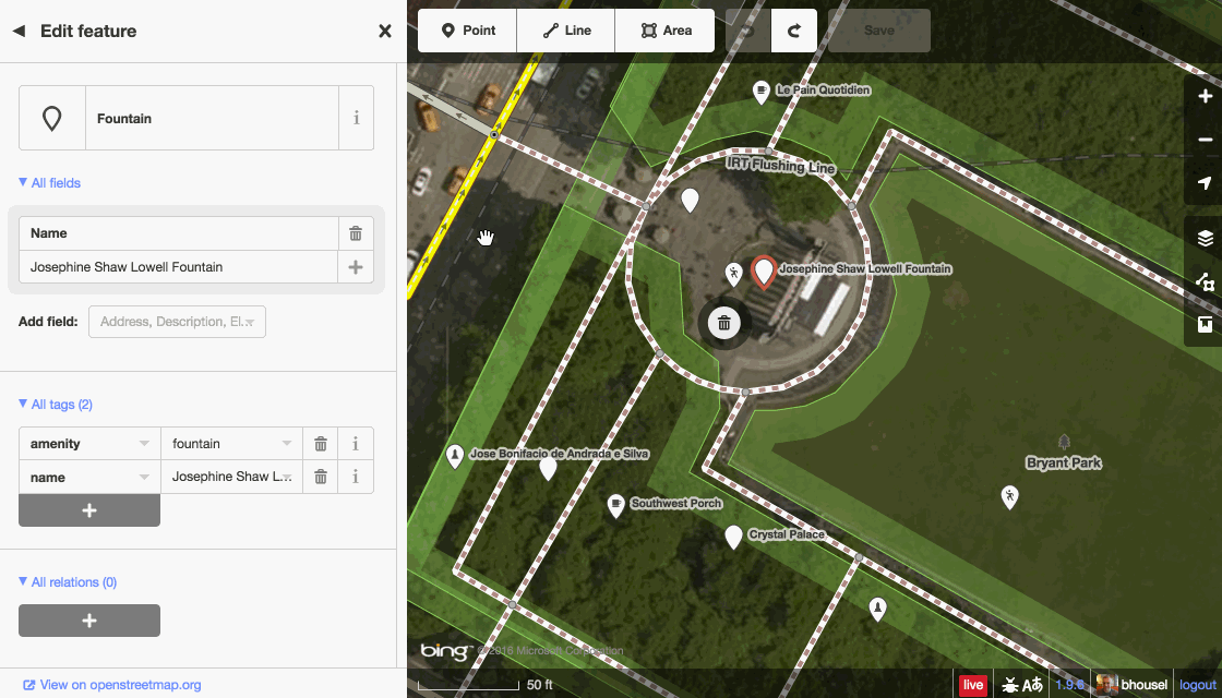
iD makes it easy to add Wikipedia and Wikidata tags to any feature.
Once an OpenStreetMap feature is linked to a Wikidata item, OpenStreetMap-powered applications can gain access to a wealth of information. For example, now that the Josephine Shaw Lowell Fountain in New York City is linked to this Wikidata item in OpenStreetMap, an application can get the fountain’s dedication year using the Wikidata API or find out the city’s mayor at the time using the Wikidata Query Service — without having to parse the Wikipedia article’s freeform text to find the answer.
Promoting quality data

The Josephine Shaw Lowell Memorial Fountain in winter. (Anthony Quintano, CC BY)
Historical, tangential, or perishable data — the dedication year of a fountain, the stock market ticker symbol of a company’s headquarters, the mayor of a city — is more appropriate for Wikidata than OpenStreetMap. OpenStreetMap-based maps would be unlikely to display such information visibly, leaving it more prone to bitrot. Wikidata, on the other hand, can surface this information through highly visible fact boxes on Wikipedia, promoting accuracy and freshness. As editors like iD encourage tighter integration between the two projects, developers will be able to create novel, insightful applications no matter where the data happens to be stored.
In the meantime, map your hometown’s landmarks, parks, and schools on OpenStreetMap using the iD editor. When you assign a Wikipedia article to a map feature, iD will automatically fill in the Wikidata tag for you.
If you’re interested in connecting OpenStreetMap to more open source and open data projects, meet us at State of the Map U.S. in Seattle, July 23–25, where you can also learn about Wikipedia’s efforts to grow closer to OpenStreetMap.

